
Recent posts
View all
How can one establish WhatsApp channels?
WhatsApp has introduced an innovative feature known as "Channels," which is designed to facilitate direct communication between users and content creators, similar to Telegram's Chann…
 Parks in Rwalpindi
Exploring the Green Oasis: Discovering the Best Parks in Rawalpindi
Rawalpindi, often referred to as the "Twin City" of Islamabad, is a bustling urban center in Pakistan with a rich cultural heritage and a vibrant community. Amidst its bustling streets and…
 Rawalpindi Metro Bus
Transforming Transportation: The Metro Bus System in Rawalpindi
Rawalpindi, a bustling city in the Punjab province of Pakistan, has undergone a significant transformation in its public transportation system with the introduction of the Metro Bus service. This sta…
 (Rawalpindi & Islamabad)
Rawalpindi Unveiled: A Snapshot of the City's Key Highlights
Rawalpindi, often referred to as Pindi, is a vibrant city located in the Punjab province of Pakistan. It serves as a major economic, cultural, and transportation hub in the region. Here are some key …
 Malls in Rawalpindi
Retail Paradise: Exploring the Best Malls in Rawalpindi
Rawalpindi, a vibrant city in Pakistan, offers a thriving shopping scene with a variety of modern shopping malls. These malls not only cater to the shopping needs of the locals but also provide a spa…
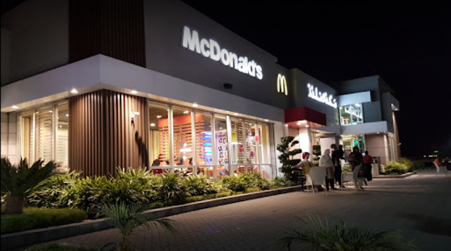 Mcdonald's Outlets
Mcdonald's Outlets in rawalpindi
All Address of Macdonald's Outlet in Rawalpindi Address: Airport Rd, Chaklala Cantt., Rawalpindi, Punjab 46000 Hours: 8AM to 12AM Phone: 0301 8502747 Address: Bahria Town, Phase 7 ,Near Green Va…
 Hajj 2020
The service will give a Refund Authority Letter, permitting the candidate to recover his stored cash.
he effective Hajj 2020 candidates, who need their stored cashback under any circumstances, have As per a warning of the Ministry, the discount structures could be acquired by clicking www.hajjinfo.or…
 PSX
PSX
Sensex on the Pakistan Stock Exchange, KSE 100 Index fell to 2139 points
Coronavirus spread around the world where the global stock market is negatively affected . There is an increase in the number of cases of this outbreak in the country as Pakistan Stock Exchange …
 Karachi Lockdown
9 more Corona virus cases reported in Sindh
Coronavirus cases are increasing day by day in the country and after 9 more cases in Sindh, the number of victims in the province has reached 181 and the total number of victims has reached 246 …
 Karachi Lockdown
Imtiaz Superstore give directions only 2 people come from one house for shopping
Karachi's driving store, Imtiaz Super Store, has given orders to expand open obtainment and maintain a strategic distance from the surge in the perspective on the Corona infection that solitar…


Social Media Icons